68/76
)
)
)
)
)
)
)
)
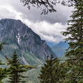
 and Ptarmigan Ridge (center-right) is Carbon Glacier, the longest, thickest, and most voluminous glacier in the United States outside Alaska. As the glacier melts, it forms the Carbon River, seen at lower right, which eventually drains into Puget Sound.")
Mount Rainier, from the north. At left is Little Tahoma Peak, a remnant of an earlier summit, before volcanic activity formed the present peak about 500,000 years ago. On the horizon at right is Mount St. Helens.
In the gap between Willis Wall (center-left) and Ptarmigan Ridge (center-right) is Carbon Glacier, the longest, thickest, and most voluminous glacier in the United States outside Alaska. As the glacier melts, it forms the Carbon River, seen at lower right, which eventually drains into Puget Sound.
- Author
- matthucke
- Created on
- Tuesday 4 August 2020
- Posted on
- Friday 7 August 2020
- Keywords
- aerial, carbon glacier, carbon river, mount rainier, mount rainier national park, volcano, washington state
- Albums
- Visits
- 859
- Rating score
- no rating
- Rate this photo
0 comments
Add a comment